Image collection »Jochberg«
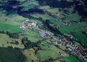
Jochberg, stretching along the gentle slopes of the Kitzbühler Grasberge Mountains, is located in the valley of the Jochberger Ache River. The village was first mentioned in a document in 1073. The centre of Jochberg is situated along the main road leading up to Pass Thurn. Some hamlets also belonging to Jochberg have undergone a considerable expansion due to the beautiful surrounding landscape within the last decades. A great number of isolated farmhouses can be found on the slopes. From the 15th till the 20th century mining on the Kupferplatte Mountain played an important role in Jochberg, which economy is characterized by tourism today.
|
|
|