Image collection »Itter«
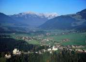
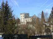
The village of Itter is situated on a terrace above the Mühl- and Brixental. This climatically und strategically well situated plateau has been settled since the Bronze Age. In the west of the village Castle Itter with its exposed position was built to guard the entrance to the Brixental. Itter furthermore encompasses Itterdörfl, some hamlets and detached farmhouses. With its beautiful geographical position, the population of Itter has increased in the last decades and several new settlements have been developed. Itter, surrounded by the gently Grasberg Mountains of the Kitzbüheler Alps, depends on the revenues generated by tourism.
|
|
|