Image collection »Wattenberg«
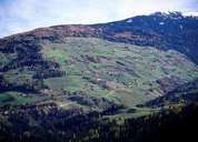
Wattenberg is situated on the eastern slopes of the Wattental. Within the last decades Wattenberg has become a popular living area, which led to an increase in population figures. Even though this phenomenon was accompanied by a rising number of houses on the mountain, Wattenberg has managed to remain a scattered village with forests, pasture lands and fields. The settlement was founded during the so called "Schwaighof Colonisation" in the High Middle Ages. The great number of farmhouses with different architectural styles is striking. In the course of generating new alpine pasture lands around the summits of the Tuxer Voralpen Mountain Range in prehistoric times, the forest had to be cleared and shifted further downhill. The attractive high valley of the Wattner Lizum with its alpine pasture and a military training ground is located south of Wattenberg.
|
|