Image collection »Tulfes«
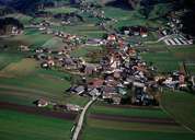
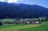
Even though Tulfes at the foot of the Glungezer Mountain (popular hiking and skiing area) is situated away from the main roads in the Inntal, it is close to the towns of Hall in Tirol (6 km) and Innsbruck (12 km). Tulfes is subdivided into the centre, which is located along the road, and the scattered villages of Tulferberg and Volderwald. The entire village stretches from the bottom of the Inntal, over the terrace with the centre, to the upper part of the Voldertal and up to the Naviser Jöchl Mountain. Tulfes is no longer a purely rural village with an emphasis on agriculture, but has also become and important dormitory town and recreational area within the proximity of the urban agglomeration of Innsbruck-Hall.
|
|
|