Image collection »Patsch«
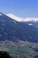
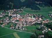
Patsch is situated on an altitude between 1100 m and 900 m, at the western foot of the Patscherkofel Mountain on the gentle slopes of a terrace, 300 m above the lower eastern Silltal. The scattered village of Patsch with its rural centre is located along the Salstraße Road and belongs to the political district of Innsbruck-Land. In the course of the reparcelling of the agricultural land of Patsch hedgerows have been planted against the strong foehn from the south. Patsch is situated above the 190 m high Europabrücke, the most important construction of the Brennerautobahn High Way, which stretches across the Silltal.
|
|
|
|