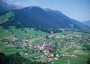
Image collection »Oberperfuss«
Oberperfuss is situated on a terrace above the Inntal on the foot of the Ranger Köpfl (1939 m) Mountain, opposite of Grinzens and above the gorge-like entrance to the Sellraintal. The village consists of the centre, several isolated farmhouses and scattered hamlets ("Riedln"). The farmhouses at the highest altitude in Oberperfuss are situated in Graß in the Tiefental (1500 m), and were built in the Middlel Ages and belonged to the Bavarian convent of Frauenchiemsee. The house of the famous cartographer Peter Anich (1723-1766) is in the village of Völsergasse. His Tirol-Karte ("Anichkarte") was a commissioned work for Empress Maria Theresia. A panorama road goes up to the vantage point of Stiegelreith (1363 m).
|
|
|