Image collection »Obernberg a.B.«
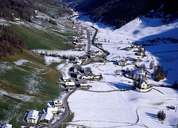
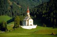
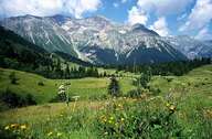
Obernberg am Brenner lies within the Obernberg Valley, which is connected with the Wipp Valley at Gries am Brenner. At the end of the valley the Tribulaungruppe Mountain Range with its steep limestone peaks is situated. Further down the valley they are linked with the gentle slopes of the Slate Mountains, which are ideal for hiking and skiing. Lake Obernberg, situated 1593 m above sea level, was formed after landslides. The Obernberg Valley was settled during the Middle Ages with isolated farmhouses. The village emblem of Obernberg commemorates the mining in this region, which took place till the 16th century. The baroque parish church of St. Nikolaus from 1760 on a hill is the most important building in Obernberg.
|
|
|
|