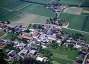
Image collection »Kolsass«
Kolsass was first mentioned in a document in 1050. The village is situated 20 km east of Innsbruck on the left side of the fan of the Weerbach Torrent. Kolsass was a typical farming community till the mid 20th century. From then onwards new houses have been built and turned Kolsass into a village with a high proportion of commuters. Kolsass (political district of Innsbruck-Land) and its neighbouring village of Weer (political district of Schwaz) on the right hand side of the fan have close connections. They share the primary school in Kolsass and the secondary school in Weer.
|
|
|