Image collection »Baumkirchen«
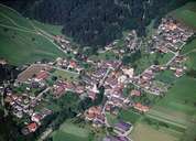
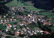
Archaeological excavations, local place names and the parish saint of Saint Laurentius clearly indicate that the region around Baumkirchen has been inhabited for a long period. Baumkirchen, situated 50 m above the Inntal on the Gnadenwald Terrace, had a thermal bath till World War II. Baumkirchen has managed to avoid modern suburban tendencies as to be found in neighbouring villages. Only in the last few years population has increased to over 1000. Even today the part of the Inntal belonging to Baumkirchen is nearly uninhabited. The clay pit in Baumkirchen is of significant scientific interest as research in it made it possible to date the duration and the end of the last ice age. Due to the clay layers many springs can be found in Baumkirchen.
|
|
|