Image collection »Ammergauer Alpen«
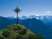
The Ammergauer Alpen, also called the Ammergebirge, are demarcated in the west by the River Lech, in the east by the River Loisach as well as the Voralpen (pre-Alps) in the north and the Lechtaler Alpen in the south and lie on both Tyrolean and Bavarian territory. This is the biggest nature preservation area in Bavaria. The highest peak is the Daniel (2340 m) which is located in Tyrol. Further major peaks are the Kramer (1985 m), the Hochplatte (2082 m) and the Kreuzspitze (2185 m).
|
|
|
|
|
|
Further links: Weblink »Wikipedia«