Image collection »Wattental«
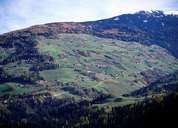
The Wattental runs in a south-north direction and joins the Inntal at Wattens. Settlements with denser populations are only to be found in valleys close to the Inntal (Wattenberg, Vögelsberg). The Watter Lizum ("Lizum" means an alpine area at the head of a valley) is a popular ski touring region. The Austrian army's second largest military training area is located here. Even as early as the Middle Ages the Wattental did not concentrate solely on agriculture; there was extensive charcoal production. Because the salt works in Hall required so much energy, one even ventured into almost inaccessible mountain regions. The charcoal was generally brought down to the valley on sleds during the winter months, because the steepness and uneven nature of the terrain made transportation too difficult in the summer. In the mid-19th century when the salt works in Hall switched over to hard coal fuel, the charcoal burning sites, which had existed for some 400 years in the thickly forested side valleys of the Inn, rapidly disappeared. The black soil still visible in places bears witness to the area's charcoal burning past.
|
|