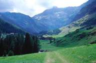
Image collection »Pfelderer Tal«
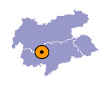
The Pfelderer Tal runs in a southwest-north-easterly direction and is a side valley of the Paseiertal. The Pfeldererbach flows into the Passer over the Stieber Wasserfälle waterfalls near Moos im Passeier at the entrance of the valley. The head of the Pfelderer Tal is part of South Tyrol's biggest nature park, the Naturpark Texelgruppe (33,430 hectares). At 1624 m Pfelders is one of the highest settlements in South Tyrol.

|
|
Further links: Hazards Chronicle Tyrol, Weblink »Wikipedia«
