Image collection »Höhlensteintal«
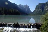
The Höhlensteintal is a north-south running side-valley of the Pustertal. While the lower stretches around the Toblacher See (Lake Toblach) are still quite broad, the upper reaches are closed in by sheer rock faces. There is an impressive view on to Monte Cristallino (2775 m) and the famous Drei Zinnen (2998 m) from the Dürrensee (Lake Dürren) also called the Landrosee (Lake Landro). The Höhlensteintal is an important old transit connection. The Strada d'Almagna (Toblach, Cortina d'Ampezzo and on in a southerly direction) was opened for postal services in 1932. In 1921 a narrow-gauge railway was opened, which was, however, closed down again in 1962 through lack of interest in the wake of increased private motorisation. There are now plans to re-open the old line with a normal gauge railway from Toblach to Calalzo (the Piave line terminal). In the 1960s the importance of the valley as a road link led to plans for a motorway Munich-Venice through the Höhlensteintal among other locations. These plans have been scrapped in the meantime because there was too much resistance among the local population and the construction of such a motorway would contravene the Alpine Convention.
|
|