Image collection »Vinschgau«
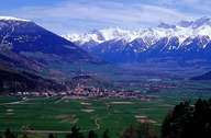
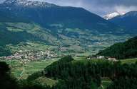
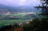
The Vinschgau stretches from the headwater of the Etsch between Reschenpass and the steep decline of the valley down to Meran - the so called Töll. The Vinschgau is a typical trough valley, which's bottom is dominated by several impressive fans from tributaries. Due to these fans the Etsch changes from one side of the valley to the other several times. Its inner alpine location is the reason for the small amount of rainfall the region gets (600 mm a year). The northern slopes, which are settled up to an altitude of 1600 m, and the bottom of the valley need intensive irrigation. Irrigation has a long tradition in the Vinschgau. The shady side of the valley is covered with forests, which reach the bottom of the valley. It is furthermore characterized by numerous settlement clearings. Important economic factors in the region are the intensive orcharding, long distance traffic over the Reschen and tourism. Only since the 1970s other economic sectors outside agriculture have gained importance. Due to the title of inheritance (Realteilung) typical for this region, the cultivated land was divided into small parcels of land. The title of inheritance made it nearly impossible to gain a living from the land, so many people moved away from this region. Even though there are industrial parks in the Vinschgau the portion of people working in the industrial sector is small.
|
|
|
|