Image collection »Schnalstal«
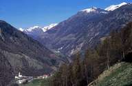
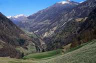
The 24km long Schnalstal runs from the Ötztaler Alps to Naturns, where it meets the Vinschgau. The discovery of the ice-man (=Ötzi) at Tisenjoch near the Similaun glacier clearly indicates that the Schnalstal has already been settled for a long time. Between 1956 and 1962 the Vernagtstausee reservoir was built. Due to the construction of the reservoir several farmhouses and the church St. Johannes auf der Leit had to give way to the project. A distinctiveness of the region is the annual sheep drive from Schnalstal over Nieder- and Hochjoch to Ötztal. In Pfossental the estate at the highest altitude in South Tyrol is situated - the so called Eishof. Schnals is part of the nature reserve Texelgruppe. The nature reserve stretches between the Etschtal in the south, the Schnalstal in the west, the Passeier in the east and the main crest of the Alps in the north.
|
|
|