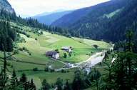
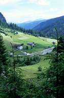
Image collection »Ratschingstal«
The landscape of the valley, which is linked with the Rinauner Tal, looks similar to the ones in the Jaufen and Ridnauner Tal. The central part of the valley is dominated by a large rock debris. The northern slopes and the central part of the valley belong to the part of the Stubaier Alpen, which is not covered with glaciers. The south-eastern part on the other hand is part of the Sarntaler Alpen. Since the 15th century marble has been quarried in the valley. This rock was used to build the parish church in Sterzing. This white marble can be found especially in the Gilfenklamm. Until the mid-1980s silver, lead and zinc blende were mined. The first settlements date back to 1380 and were built in the course of the Schwaighof plantations.
|
|
|