Image collection »Pustertal«
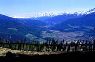
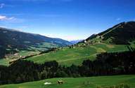
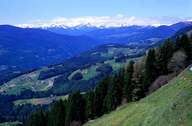
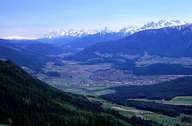
The Pustertal is one of the most important lifelines and traffic routes in South Tyrol. In the north it consists of crystalline rocks of the Zentralalpen and of lime stones of the Dolomites in the south. The valley stretches from west to east. It even stretches over the watershed of Rienz and Drau to the entrance of the Drautal in Osttirol. The landscape of the valley changes several times: the lower part of the Rienz valley is not very wide, which narrows due to alluvial fans. Most of the settlements can be found on the fans on the northern slopes of the valley. The Pustertal divides the Zentralalpen from the Südalpen. Toblach, the village with the coldest average temperature in South Tyrol, lies within the Pustertal. First traces of early settlements can be traced back till the Neolithic period. Under Bavarian rule a monastery was founded in Innichen, which was responsible for the colonisation and proselytisation of the valley. In World War I the valley was hard fought over. Since World War II the valley has changed from a agricultural dominated towards a tourism dominated region.
|
|
|
|
|
|