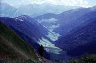
Image collection »Jaufental«
The Jaufental, which belongs to Ratschings, meets the Ridnauner Tal gorge-like southwest of Sterzing. It no longer has a purely high alpine character, such as the Stubaier Alpen, but it is already a part of the Sarntaler Alpen, which are already part of the crystalline Ötztaler Masse. The steep northern slopes of the narrow, crescent-shaped valley are forested. Due to several rivers the southern slopes are more structured. Because of the steep slopes settlements, which reach an altitude of 1400 m, can only be found on the southern slopes in the lower part of the valley. Only the part of the valley which runs from west to east and the less steep slopes on the northern side are settled. In Außerthal one reaches the Sarntal over the Penser Joch. In former times this was an important route from and to Sterzing. A road has linked the valley with the Passeier over the Jaufen since 1912.
|
|
|