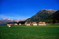
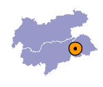
Image collection »Gsieser Tal«
The Gsieser Tal is the most eastern tributary valley of the Pustertal. The valley has its entrance near Welsberg and runs 20 km long up to the Deferegger Alps. The valley is characterized by its plateau-like character, which stretches over the mountain crests. The many low and gentle passes to the neighbouring valleys were once likewise used by pilgrims and smugglers. Due to the gentle character of the landscape the Gsieser Tal is dominated by alpine pastures. The first settlers were Bavarians, which built their settlements in clearings on the sunny slopes. Dairy farming and cattle breeding dominated the valley. Today the valley is a popular housing area. Most of the working people commute to Bruneck in the Pustertal for work.

|
|
