Image collection »Venter Tal«
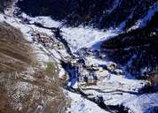
The Venter Tal (15 kms long) branches off in a south-westerly direction at the end of the Ötztal. The Venter Ache has cut itself a deep valley into the crystalline rocks of the Ötztaler Massif. With the exception of Vent, the valley is sparsely populated. The Rofenhöfe farms, which stretch valley inwards from Vent at an altitude of 2011m, make up the highest permanent settlement in the Eastern Alps.
|
|