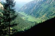
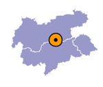
Image collection »Valser Tal«
The Valser Tal is a six kilometre long side valley of the Wipptal. This valley that joins the Schmirntal at St. Jodok, runs into the Nordtiroler Wipptal at Stafflach. The area of the Valser Tal was initially used by the farmers from Mauern near Steinach as mountain pasture land. At the head of the valley the 35km² nature reserve Valser Tal stretches as far as the Tuxer Hauptkamm. The southern slopes are dry and are in general unwooded and have been used as mountain meadows for centuries. The northern slopes are wooded up to about 1900m; patches of Swiss pine grow even higher. The valley floor is used as farmland.

|

|
|
