Image collection »Reuttener Becken«
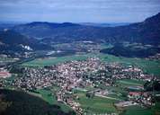
The Reuttener Becken was washed out and formed by the River Lech and the Lech glacier. Its boundary is a circle of mountains consisting of limestones of differing resistance which fall off to the north. Despite the unfavourable climate, the region has, because of natural conditions, developed into the focal point of the district with the market town of Reutte at its centre. All important transport routes from the South German region from Zwischentoren, the Lechtal and the Tannheimertal converge here. Furthermore, the Reuttener Becken, together with Breitenwang, has been one of the most industrialised regions in Tyrol for decades. Downstream a further basin formed by the Lech with two village-like settlements as well as the small town of Vils on the Bavarian border belong to the extended catchment area of Reutte.
|
|
|