Image collection »Alpbachtal«
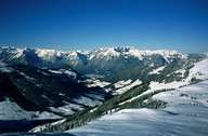
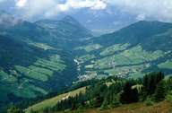
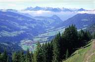
The Alpbachtal is an approximately 20km-long side valley that coming from the south meets the Inntal at Brixlegg. The local administration of the valley lies in the hands of the communities of Reith im Alpbachtal and Alpbach. However, the Alpbachtal proper only begins behind a geological ravine south of Reith. The landscape, characterised by the soft slate and grauwacken zones, offers good prerequisites for farming and alpine farming as well as winter and summer tourism. The in-part old log-cabin style farmhouses lend the cultural landscape of the Alpbachtal its unmistakable character. The Alpbachtal has become internationally known through the "European Forum Alpbach" held annually in Alpbach since 1945.
|
|
|
|
Further links: Hazards Chronicle Tyrol, Weblink »Wikipedia«