Image collection »Partnachklamm Gorge«
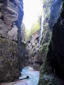
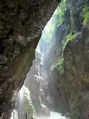
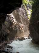
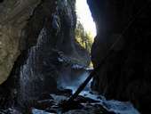
In the Reintal valley, to the south of Garmisch Partenkirchen, lies the impressive, approx. 800 m. long Partnachklamm gorge. This narrow valley shape was formed by the erosive power of the Partnach mountain torrent which meets on hard shell limestone here cutting a deep gorge which, in places, reaches a depth of some 80 m. To the north and south of the Partnachklamm gorge, the valley contours are broader and gentler, due to the softer and therefore more easily eroded rock. From the 19th century up to the 1960s the river and gorge were important, above all, in the transportation ("triften" - seasonal wood transportation) of firewood from the back of the Reintal to Partenkirchen. Nowadays, the Partnachklamm is open to tourism and, for example, guided hikes are offered which lead through the gorge, past numerous waterfalls, torrents and gumpen. The gorge was already declared a monument of natural beauty in 1912. In the meantime, the Partnachklamm ranks among the 100 most beautiful geotopes in Bavaria.
|
|
|
|
|
|