Image collection »Kundler Klamm Gorge«
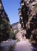
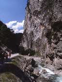
The Kundler Klamm gorge which is approximately 2.5 kilometres long and stretches from the community of Kundl to the Mühltal valley was formed by the waters of the Wildschönauer Ache. The visitor gets to see mighty and bizarre rock formations and eroded shapes, and in places coloured traces of silver, copper and granite are visible. Up to the first half of the 20th century, the Wildschönauer Ache, and therefore also the Kundler Klamm, served as a transportation route for wood. In those days the region of the Wildschönau was an important wood supplier for the west of Austria. Nowadays the Kundler Klamm is open to the public and the broad and generally flat gravel paths make it leisurely to walk through. Rare plants such as the dwarf alpine rose (Lat. Rhodothamnus chamaecistus) or the gold auricular (Lat. Primula auricular; Platenigl) can be seen here and there along the wayside.
|
|
|