Image collection »Gaichtpass«
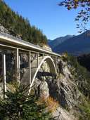
The Gaichtpass (1073 m) is a narrow point in the Außerfern which connects the Lechtal valley with the Tannheimer Tal valley and later also with Germany over the Oberjoch. During the Middle Ages the important "Salt Route" between Tyrol and Allgau ran along here. However, in those days it was only a narrow mule track. Around 1550 a new road was constructed and a fort was soon built. In the 20th century a further extension to the road took place that now runs 150 m above the Weißenbach. The Gemstobelbrücke bridge, which was destroyed in 1945, was only reopened in 1979.
|
|
Further links: Weblink »Wikipedia«