Image collection »Säben«
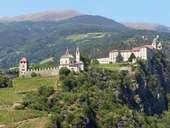
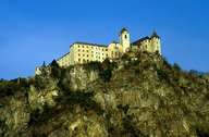
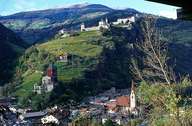
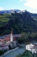
The castle hill high above Klausen and the River Eisack on which the present-day Säben monastery is located was already settled 6000 years ago as prehistoric finds have shown. However, Säben is first mentioned around 350 AD. Despite its decentralised location, Säben was made a bishopric in the 6th century. Since 1681 the castle has served as a Benedictine monastery. Although the monastery is not open to the public, highlights such as the Liebfrauenkirche (Blessed Virgin Church), the Gnadenkapelle (Chapel of Mercy), or the Heilig-Kreuz-Kirche (Church of the Holy Cross) can be admired. Because of its imposing location high above Kausen and the Eisacktal valley, the monastery of Säben is frequently called the "Tyrolean Acropolis".
|
|
|
|
|
|
Further links: Weblink »Säben«, Weblink »Wikipedia«